Hattusa (also known as Hattusas, Hattusha or Khattushash) was the capital of the Hittite Empire. It was located near the modern-day village formerly known as Boğazköy, now named Boğazkale (40°01′N 34°36′E), a district center in Çorum province, Turkey, and was set in a loop of the Kızılırmak river (Marashantiya in Hittite sources and Halys in Antiquity) in central Anatolia, about 145 km (90 miles) north-east of Ankara.
The surroundings
The landscape surrounding the city included rich agricultural fields, hill lands for pasture, as well as woods. Smaller woods are still found outside the city but in ancient times there were much more. This meant the inhabitants had a great supply for timber when building their houses and other structures. The fields provided the people with a subsistence of wheat, barley and lentils. Linen was also harvested , but their primary source for clothing was wool from sheep. They also hunted deer in the forest, but this was probably only a pleasure by the nobility. The source for meat was domesticated animals. There were several other settlements in the vicinity, such as the rock shrine at Yazılıkaya and the town at Alacahöyük. Since the rivers in the area are too small and unsuitable for major ships, all transport to and from Hattusa had to go by land.
Early history of the city
Before 2000 BC a settlement of the apparently indigenous Hatti people was established on sites that had been occupied even earlier. The earliest traces of settlement on the site is from the Sixth Millennium BC. In the 19th and 18th centuries BC, merchants from Ashur in Assyria established a trading post here, setting up in their own separate quarter of the city. The center of their trade network was located in Kanesh (Nesha), the archaeological site known as Kültepe near Kayseri. Business dealings required record-keeping: the trade network from Ashur introduced writing to Hattusa, in the form of cuneiform.
A carbonized layer in the excavations records the burning and ruin of the city of Hattush around 1700 BC. The responsible party appears to have been King Anitta from Kushar (a city possibly to be identified with Alişar), who took credit for the act and erected an inscribed curse for good measure:
At night I took the city by force; I have sown weeds in its place. Should any king after me attempt to resettle Hattush, may the Weathergod of Heaven strike him down.
The Hittite Imperial City
Only a generation later, a nashili-speaking king had chosen the site as his residence and capital. Here, "Nesian", an Indo-European language, had been gaining speakers at hattili`s expense for some time. The Hattian Hattush now became the Nesian Hattusha, and the king took the name of Hattusili I, the "one from Hattusha." Hattusili marked the beginnings of a non-Hattian-speaking "Hittite" state, and of a royal line of Hittite Great Kings - 27 of whom are now known by name.
After the Kaskas arrived to the kingdom's north, they twice attacked the city to the point where the kings had to move the royal seat to another city. Under Tudhaliya I, the Hittites moved north to Sapinuwa, returning later. Under Muwatalli II, they moved south to Tarhuntassa but assigned Hattusili III as governor over Hattusa. Mursili III returned the seat to Hattusa, where the kings remained until the end of the Hittites.
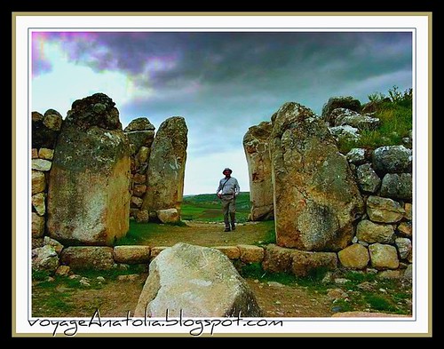
At its peak, the city covered 1.8 km² and comprised an inner and outer portion, both surrounded by a massive and still visible course of walls erected during the reign of Suppiluliuma I (circa 1375 BC-1335 BC). The inner city covered an area of some 0.8 km² it was occupied by a citadel with large administrative buildings and temples.
To the south lay an outer city of about 1 km², with elaborate gateways decorated with reliefs showing warriors, lions, and sphinxes. Four temples were located here, each set around a porticoed courtyard, together with secular buildings and residential structures. Outside the walls are cemeteries, most of which contain cremation burials. Modern estimates put the population of the city between 40,000 to 50,000 at the peak. In the early period the inner city housed a third that number. The dwelling houses which were built by timber and mud bricks have vanished from the site leaving only the stone-built-walls of temples and palaces.
The city was destroyed around 1200 BC, leading to the collapse of the Hittite empire. The site was subsequently abandoned until the mid 1st millennium BC. There are several Phyrgian settlements at the site.
Discovery of the city
Since 1906, the Deutsche Orientgesellschaft (the German Institute of Archaeology) has been excavating at Hattusa (with breaks during the two World Wars and the Depression). Archaeological work is still carried out by the German Institute of Archaeology (Deutsche Archäologische Institut). Hugo Winckler and Theodor Makridi Bey conducted the first excavations 1906, 1907 and 1911-13. One of its most important discoveries has been the cuneiform royal archives of clay tablets, consisting of official correspondence and contracts, as well as legal codes, procedures for cult ceremony, oracular prophecies and literature of the ancient Near East. One particularly important tablet details the terms of a peace settlement between the Hittites and the Egyptians under Ramesses II, circa 1283 BC. A copy is on display in the United Nations in New York as an example of one of the earliest known international peace treaties.
Although the 30,000 or so clay tablets recovered from Hattusha form the main corpus of Hittite literature, archives have since appeared at other centers in Anatolia, such as Tabigga/Maşat Höyük (in Tokat Province) and at Shapinuwa/Ortaköy. They are now divided between the archaeological museums of Ankara and Istanbul.
Hattusha is also one of nine sites in Turkey currently included in the UNESCO World Heritage List.