Purushanda (also variously Purushkanda, Purushhattum or Burushattum) was an ancient city-state in central Anatolia, lying south of the Kızılırmak River in what is now modern Turkey. Its site has yet to be discovered. It may have been situated south-east of Lake Tuz, possibly on the mound of Acemhöyük approximately 6 kilometres (3.7 mi) north-west of the city of Aksaray. Another possible location is the mound of Karahöyük near Konya.
The city is prominently mentioned in the Cappadocian Texts, a collection of Hittite writings unearthed at Kanesh. They depict it as a major seat of power in the region, describing its ruler as "great prince" (rubā'um rabi'um) whereas other rulers are merely "kings". A separate text known as the "King of the Battle" (šar tamhāri), dating to the 14th century BC, recounts a heavily embellished account of the Akkadian king Sargon carrying out an expedition against Purushanda's ruler Nur-Dagan (or Nur-Daggal). The story is ahistorical, as it portrays the 23rd-century Sargon in an anachronistic 19th-century BC setting. It appears to be a work of fiction, though it may have some basis in historical fact.
In the story, Sargon yearns for battle but is advised against it by his generals. Nonetheless, when a message arrives from a group of Akkadian merchants in Purushanda pleading for help from Sargon against the oppressive Nur-Dagan, the king mobilises his army and marches off through difficult terrain. Nur-Dagan is hopeful that flooding and the terrain will thwart Sargon, but the Akkadian launches a lightning attack which captures Purushanda. Nur-Dagan is taken prisoner and grovels before Sargon, declaring him to be a peerless mighty king and perhaps swearing allegiance as a vassal. After three years the Akkadians leave, taking with them the fruits of the land as spoils of war.
Purushanda features again in the stories of the campaigns of the 17th century BC Hittite ruler Anitta. The Purushandan kingdom appears to have been a significant rival of Kanesh, the kingdom ruled by Anitta. The Hittite king launched a war against Purushanda but according to the Anitta Text, a Hittite account of later date, the Purushandan king surrendered to the Hittite army:
"When I ... went into battle, the Man of Purushanda brought gifts to me; he brought to me a throne of iron and a sceptre of iron as a gift. But when I returned to Nesa [Kanesh] I took the Man of Purushanda with me. As soon as he enters the chamber, that man will sit before me on the right.
The text indicates that the right to rule over Purushanda's territory – symbolised by the regalia of office, the throne and sceptre – was surrendered to Anitta. Its king was reduced to the status of a privileged vassal, entitled to join Anitta at the court in Kanesh in recognition of his voluntary surrender and his high-born status. The kingdom itself probably ceased to exist at this point and was absorbed into Hittite-ruled territory." wikipedia
The main product of Purušḫanda was silver, which was usually exchanged for copper, tin and textiles. There was also a smuggling of textiles between Kaniš and Purušḫanda . In Purušḫanda decimal system, while in the Assyrian Kaniš sexagesimal system was used. There is also evidence that it had its own units. wikipedia
Location of Acemhoyuk
Acemhöyük, Ancient Anatolian City, is located within the territory of the Yeşilova District, 18 km northwest of the Aksaray Province. It is easily accessible through the Aksaray-Yesilova motorway.
Geography and Environment of Acemhoyuk
Acemhöyük looks like a flat hill from a far distance. It is reported to measure ca. 800 x 700 m in dimensions according to the distribution of the pottery. The size of the EBA settlement couldn't be verified by the researchers. Almost completely obscured by the modern Yesilova houses, it has been saved from the possible damages after the excavation was started. The Melendiz Stream (Uluirmak) originating from the Melendiz Mountain, used to pass by the hill to spill into the Lake Tuz. Today, it disappears in the plain before reaching the lake as it is used for irrigation purposes.
Overview of Ancient Acemhoyuk
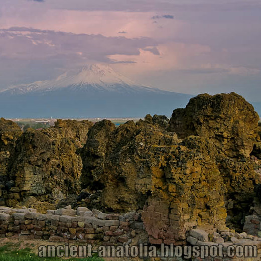
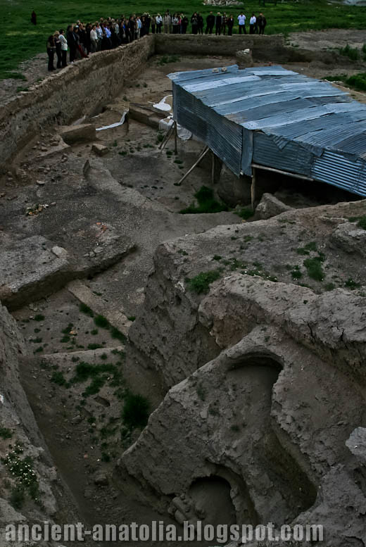
The Ancient Site of Acemhöyük (ancient Purushanda/Burushattum) consists of a large mound (700 x 600 m) and lower city. The mound itself consists of four high points, with flat areas between, and has occupation going back into the 3rd millennium, but the lower city was occupied only in the Assyrian Colony period. Both areas were abandoned at the end of that time. Levels I and II were disturbed and excavation has concentrated on level III, the burnt level contemporary with Kültepe Karum II, which has produced two palaces on the high points of Sarıkaya and Hatipler and the West Building on the third high point, as well as other buildings in between. The cemetery was some 500 m from the mound.
Excavations at the site began in 1962 under the direction of Prof. Dr. Nimet Özgüç (AU-DTCF) and have continued since 1989 under Prof. Dr. Aliye Öztan (AU-DTCF).
Around 1950 B.C., traders from the northern Mesopotamian city of Ashur established karums, or merchants' colonies, at a number of Central Anatolian cities, among them the site of Acemhöyük. Assyrian merchants lived in a restricted area of these cities, trading textiles and tin from the southeast for silver but operating under the rule of local kings. Acemhöyük is a large mound located south of Ankara near the Turkish city of Aksaray on the Konya Plain. It lay on a route linking Anatolia with the East and seems to have been an important center for the copper trade and industry. In 1965, a Turkish archaeological expedition found sealed bullae, inscribed clay tablets, ivories, and other objects outside the karum of Acemhöyük in two burned palaces on the highest part of the mound.
Acemhöyük is one of the biggest tumuli of Anatolia, beside Aşağı Şehir. The data obtained from the archaeological diggings shows that the tumulus was erected in BC 3000 and the most successful period of the tumulus was seen in the Assyrian Trade Colonies Period, that is in BC 1800. In the Colony Period, Aşağı Şehir was also a large settlement area beside the tumulus. It is the center of one of Anatolia's important kingdoms in this period. At the end of this period, both the tumulus and Aşağı Şehir were deserted. However, settlement occurred in the tumulus in the Early Hellenistic and Rome Periods. The tumulus was completely deserted at the beginning of the 3rd century A.D. 3 nomad families, who came from Hoy City of Azerbaijan / Iran in 1517, settled at the foot of the tumulus and founded today's Yeşilova.
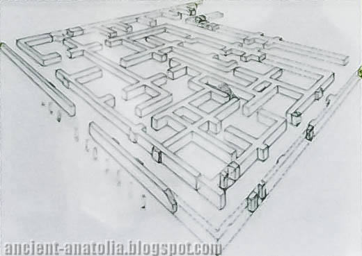
Two palaces found in the 3rd level belonging to the Colony Period, the most successful period of the city, is not only important for Acemhöyük, but also for Anatolian architectural history. The palace at the south side of the tumulus is called Sarıkaya, and the one at the north - west is called Hatipler Palace.
Mac North and Maryanne Newton are finishing putting together a 546-year juniper chronology from 68 pieces (possibly 15 trees) from Building Level III in the Northwest Trench at Acemhöyük. At Acemhöyük, an enormous mound (800m N-S x 800m E-W) only a fraction of which has been investigated, excavator Prof. Aliye Öztan (Ankara) thinks that the rooms of the Northwest Trench are service buildings, or kitchens, for the palatial Hatipler Tepesi to the east for which we already have a wiggle-matched dendrochronological date of 1791 B.C.±37 years. Eleven ovens were excavated during the summer of 1993 from this new area.
Although the finds (wheelmade pottery, bullae, bronze objects, etc.) are clearly Middle Bronze Age, and the violent destruction which brought the lives of most of the Northwest Trench buildings to an end is thought to be the same destruction that burned Hatipler Tepesi and the Sarikaya Palace some 400 meters to the southeast, the timbers which served as footings for the walls of these buildings do not crossdate at all with the Middle Bronze Age master chronology. As a glance at Fig. 3 below will show, inside an unburned section of mudbrick wall with its two white plastered faces left and right are horizontal stretchers with charred ends, a classic example of reused and recycled material. Indeed, the left and right timbers are joining half-sections of the same tree. The one chronology with which they do fit securely is the 198-year sequence from Levels 6/7 at Konya-Karahöyük which Professor Sedat Alp (Ankara) thinks is contemporary with the Alaca Höyük royal graves about the middle of the third millennium B.C. These stretchers were probably posts in burned EBA buildings which were demolished to make way for the MBA service buildings now being excavated. It is odd, if not out-right distressing, that so far not one single piece of wood from these buildings has a Middle Bronze Age cutting date. If, as now seems likely, we are able to attach the new 546-year Acemhöyük series to the early end of the 1761-year Bronze Age/Iron Age chronology, we should have a continuous chronology well over 2000 years long. This would extend this long sequence back to 2922 B.C., but that depends on a tenuous overlap that has not yet been worked out as of November 1993.
For instance, the first juniper sample from the Kayran Mevkii Tumulus near Gordion, collected in a salvage operation by personnel from the Museum of Anatolian Civilizations in Ankara, took Maryanne Newton all of 45 minutes to prepare, measure, and crossdate to 862 BC. By contrast, three large boxes from a large building at Acemhöyük, just north of the Sarikaya Palace, sent to us by Prof. Aliye Öztan, have occupied 15 people for a month, and the end is not yet in sight, even though the majority of the 60+ samples were poplar and consequently undatable. There are, however, some 15 pieces of pine and long-lived oak with microscopic rings—all in what is now an essentially treeless plain just south of the Great Salt Lake. The oak and pine appear to be datable (Maryanne is still working on it) against wood collected in earlier years from both Acemhöyük and Kültepe and wiggle-matched in place with a low error margin.
Team members for the summer 2002 collecting trip were Pam Sullivan (who has succeeded Jennifer Chiment as Lab Supervisor), students Laura Reis and Whitney Tassie, and Government Representative Nilüfer Karakas from the Antalya Museum. We came back at the end of August with a third of a ton of wood and charcoal, augmented last month by the charcoal from Acemhöyük. In the lab this term 20 people are working away on the summer’s haul, including old-timers Kelly Jenks, Defne Bozkurt, and Beth Ryan in addition to the summer crew.
Around 1950 B.C., traders from the northern Mesopotamian city of Ashur established karums, or merchants' colonies, at a number of Central Anatolian cities, among them the site of Acemhöyük. Assyrian merchants lived in a restricted area of these cities, trading textiles and tin from the southeast for silver but operating under the rule of local kings. Acemhöyük is a large mound located south of Ankara near the Turkish town of Aksaray on the Konya Plain. It lay on a route linking Anatolia with the East and seems to have been an important center for the copper trade and industry. In 1965, a Turkish archaeological expedition found sealed bullae, inscribed clay tablets, ivories, and other objects outside the karum of Acemhöyük in two burned palaces on the highest part of the mound.
A group of ivories given to the Metropolitan Museum of Art in the 1930s is thought to have come from Acemhöyük because of close similarities in style and subject to those known to have been found there. Ranging in color from white to gray blue and a pinkish orange, they have been carved to represent the fantastic composite creatures important in the mythology of the ancient Near East. This small female sphinx is a form borrowed from the Egyptians. Her large almond-shaped eyes and spiral locks ultimately derive from the Egyptian goddess Hathor. As with the later ivories from Nimrud, this sphinx, one of four in the Museum, was carved as furniture decoration.
Source: Furniture support: female sphinx with Hathor-style curls [Probably Acemhöyük, Central Anatolia] (32.161.46) | Heilbrunn Timeline of Art History | The Metropolitan Museum of Art metmuseum.org
Situated in a fertile plain 13 km north-west of Aksaray at the south edge of the Tuz Gölü and on the main north-south and east-west routes, this site (ancient Purushanda/Burushattum) consists of a large mound (700 x 600 m) and lower city. The mound itself consists of four high points, with flat areas between, and has occupation going back into the 3rd millennium, but the lower city was occupied only in the Assyrian Colony period. Both areas were abandoned at the end of that time. Levels I and II were disturbed and excavation has concentrated on level III, the burnt level contemporary with Kültepe Karum II. It has produced two palaces on the high points of Sarıkaya and Hatipler and the West Building on the third high point, as well as other buildings in between. The cemetery was some 500 m from the mound. Excavations at the site began in 1962 under the direction of Nimet Özgüç and have continued since 1989 under Aliye Öztan of Ankara University. une.edu.au
Acemhöyük (Ancient Anatolian City of Acemhoyuk-Aksaray)
Location of Acemhoyuk: Acemhöyük, Ancient Anatolian City, is located within the territory of the Yesilova (Yeşilova) District, 18 km northwest of the Aksaray Province. It is easily accessible through the Aksaray-Yesilova motorway.
Geography and Environment of Acemhoyuk: Acemhöyük looks like a flat hill from a far distance. It is reported to measure ca. 800 x 700 m in dimensions according to the distribution of the pottery. The size of the EBA settlement couldn't be verified by the researchers. Almost completely obscured by the modern Yesilova houses, it has been saved from the possible damages after the excavation was started. The Melendiz Stream (Uluirmak) originating from the Melendiz Mountain, used to pass by the hill to spill into the Lake Tuz. Today, it disappears in the plain before reaching the lake as it is used for irrigation purposes
Early Bronze Age
Research and Excavations in Acemhoyuk: Acemhöyük was excavated by Prof. N. Özgüç of Faculty of Language, History and Geography, University of Ankara between 1962 and 1988. The excavation was taken over by Prof. A. Öztan from the same faculty in 1989, and it still continues. The recent excavations are focused on Assyrian Colony Period. It takes place in the registered archaeological sites list prepared by Ministry of Culture and Tourism.
Stratigraphy:Ancient Acemhöyük site had been inhabited from the EBA to the Roman Period. Among others, the settlement of Assyrian Colony Period dating from the first quarter of the second millennium BC is particularly significant with its famous palaces and finds. Because the excavations were targeted revealing the settlements of the second millennium BC, the deeper levels were not excavated extensively. The EBA levels were only reached through a deeper sounding on the east of the mound. The building levels VIII-X uncovered in the trench S are dated to the EBA II-III periods. Depending on the surface finds of the first settlement, it is claimed the first occupation started during the Last Chalcolithic Age [Yakar 1985:199].
Findings & Observations in Acemhoyuk:
Architecture: Acemhöyük excavations yielded a village architecture consisting of mudbrick structures with rectangular or crooked plans from the EBA period. The houses with stone foundations are thought to have flat roofs. The floors are of compressed soil. Because of the lack of an extensive research for areas belonging to this age, the settlement plan is yet to be identified.
Ceramics: Sherds of the EBA ware in the Central Anatolian style were recovered. They are handmade in the lower building levels whereas wheel made in the upper levels. The building level 9 yielded sherds of the red burnished group of ware as well as the wheel made, buff coloured coarse group of ware decorated with bands and hatchings by red paint. The building level 10 included sherds comparable with the ones recovered at EBA II of Gözlükule (Tarsus) [Mellink 1983:431]. The wavy sherds disappear with this level and handmade monochrome sherds appear. Samples of the metallic ware from Central Anatolia are also found.
Clay: Loomweights were found in the building level 10. The weights found in situ reveal that the stone paved room was a weaving room [Özgüç (N) 1984:110].
Ground stone: Fragment of a Cappadocian style marble idol was recovered from the building level 8 identical to the ones recovered in the building levels 13-12 of Kültepe (Kayseri) [Özgüç (N) 1984:110]. This is the only sample found outside Kültepe. It has a pointed head, a long neck and a round body. Obviously it is a evidence of the relationship between the two settlements during the end of the third millennium BC. Bone/Antler: Very restricted number of bones was found. The radiating circles on all four sides of an ivory object look exactly like the circle decorations of marble idols at Kültepe. This is another evidence to prove the relation between the two settlements.
Human Remains: Both extramural and intramural burials were found. When the burial practices of EBA are taken into consideration, the number of simple pit burials or pithos graves is poor in the settlement. N. Özgüç claims that the extramural cemetery is located on the side facing Aksaray depending on the grave found in the field owned by M. Mengi on the Yesilova-Aksaray road. A cup and a depas made of a slow wheel were found here [Özgüç (N) 1980:621]. In addition, the exposure of two pithos graves recovered under the floor of a house with stone foundation in the area BB/51 of the building level 10 indicates, even tough seldom, the presence of intramural burials [Özgüç (N) 1993:517-520]. One of the pithoi is washed in reddish brown has a sand-tempered paste. It contains no grave goods. The other pithos is 68 cm in height and in better condition. It is of red washed, burnished ware. There are two small handles on the shoulders of the vessel. It includes an infant burial just like the other one. It yielded two small copper bracelets, a golden hair pin and various sizes of miniature pottery as grave goods [Özgüç (N) 1993:fig.2/1-2].
Interpretation and Dating: The EBA I settlement of Acemhöyük revealed not only the Central Anatolian but also Mesopotamian and North Syrian pottery. It demonstrates that the interaction between Acemhoyuk, localized as Prushanda later and the other places had started in the third millennium BC. As the excavations conducted by N. Özgüç and A. Öztan were mainly concerned with the second millennium BC, the period of the third millennium of this significant mound is not well known. The mound may be an important city as a citadel of EBA I. The layer IX was dated to the early third millennium BC because of a finding, a bottle which undeniably belonged to Syria [Özgüç (N) 1979:890]. The two handled cup (depas) is said to be in the style of Akkads from the King Naramsin period. N. Özgüç basically dates the building level X to the end of EBA II -beginning of EBA III depending on the two pithos graves and their findings. There is a discrepancy in the dating of the building levels.
It has been revealed that the Acemhöyük mound had been inhabited from the Early Bronze Age until the Roman Period. The EBA layers were uncovered only in the eastern part of the mound during a deep sounding. The building levels VIII-X in the trench S are dated back to the EBA II-III. All dates are based on the palace complex, which had been undergone a fire, dating to the Middle Bronze Age. Furthermore, the dates taken from a juniper tree from the EBA layer of Acemhöyük went far back to BC 2671-2169 (Kuniholm 1996:331).
References
Prof. Aliye Oztan
Prof. N. Ozguc
Data Base of The Archeological Settlements of Turkey-Tay Project
Acemhöyük (Aksaray)
Situated in a fertile plain 13 km north-west of Aksaray at the south edge of the Tuz Gölü and on the main north-south and east-west routes.
This Acemhöyük site (ancient Purushanda/Burushattum) consists of a large mound (700 x 600 m) and lower city. The mound itself consists of four high points, with flat areas between, and has occupation going back into the 3rd millennium, but the lower city was occupied only in the Assyrian Colony period. Both areas were abandoned at the end of that time. Levels I and II were disturbed and excavation has concentrated on level III, the burnt level contemporary with Kültepe Karum II, which has produced two palaces on the high points of Sarıkaya and Hatipler and the West Building on the third high point, as well as other buildings in between. The cemetery was some 500 m from the mound.
Excavations at the site began in 1962 under the direction of Prof. Dr. Nimet Özgüç (AU-DTCF) and have continued since 1989 under Prof. Dr. Aliye Öztan (AU-DTCF).
Around 1950 B.C., traders from the northern Mesopotamian city of Ashur established karums, or merchants' colonies, at a number of Central Anatolian cities, among them the site of Acemhöyük. Assyrian merchants lived in a restricted area of these cities, trading textiles and tin from the southeast for silver but operating under the rule of local kings. Acemhöyük is a large mound located south of Ankara near the Turkish city of Aksaray on the Konya Plain. It lay on a route linking Anatolia with the East and seems to have been an important center for the copper trade and industry. In 1965, a Turkish archaeological expedition found sealed bullae, inscribed clay tablets, ivories, and other objects outside the karum of Acemhöyük in two burned palaces on the highest part of the mound.
Acemhöyük is one of the biggest tumuli of Anatolia, beside Aşağı Şehir. The data obtained from the archaeological diggings shows that the tumulus was erected in BC 3000 and the most successful period of the tumulus was seen in the Assyrian Trade Colonies Period, that is in BC 1800. In the Colony Period, Aşağı Şehir was also a large settlement area beside the tumulus. It is the center of one of Anatolia's important kingdoms in this period. At the end of this period, both the tumulus and Aşağı Şehir were deserted. However, settlement occurred in the tumulus in the Early Hellenistic and Rome Periods. The tumulus was completely deserted at the beginning of the 3rd century A.D. 3 nomad families, who came from Hoy City of Azerbaijan / Iran in 1517, settled at the foot of the tumulus and founded today's Yeşilova.
Two palaces found in the 3rd level belonging to the Colony Period, the most successful period of the city, is not only important for Acemhöyük, but also for Anatolian architectural history. The palace at the south side of the tumulus is called Sarıkaya, and the one at the north - west is called Hatipler Palace.
Mac North and Maryanne Newton are finishing putting together a 546-year juniper chronology from 68 pieces (possibly 15 trees) from Building Level III in the Northwest Trench at Acemhöyük. At Acemhöyük, an enormous mound (800m N-S x 800m E-W) only a fraction of which has been investigated, excavator Prof. Aliye Öztan (Ankara) thinks that the rooms of the Northwest Trench are service buildings, or kitchens, for the palatial Hatipler Tepesi to the east for which we already have a wiggle-matched dendrochronological date of 1791 B.C.±37 years. Eleven ovens were excavated during the summer of 1993 from this new area.
Although the finds (wheelmade pottery, bullae, bronze objects, etc.) are clearly Middle Bronze Age, and the violent destruction which brought the lives of most of the Northwest Trench buildings to an end is thought to be the same destruction that burned Hatipler Tepesi and the Sarikaya Palace some 400 meters to the southeast, the timbers which served as footings for the walls of these buildings do not crossdate at all with the Middle Bronze Age master chronology. As a glance at Fig. 3 below will show, inside an unburned section of mudbrick wall with its two white plastered faces left and right are horizontal stretchers with charred ends, a classic example of reused and recycled material. Indeed, the left and right timbers are joining half-sections of the same tree. The one chronology with which they do fit securely is the 198-year sequence from Levels 6/7 at Konya-Karahöyük which Professor Sedat Alp (Ankara) thinks is contemporary with the Alaca Höyük royal graves about the middle of the third millennium B.C. These stretchers were probably posts in burned EBA buildings which were demolished to make way for the MBA service buildings now being excavated. It is odd, if not out-right distressing, that so far not one single piece of wood from these buildings has a Middle Bronze Age cutting date. If, as now seems likely, we are able to attach the new 546-year Acemhöyük series to the early end of the 1761-year Bronze Age/Iron Age chronology, we should have a continuous chronology well over 2000 years long. This would extend this long sequence back to 2922 B.C., but that depends on a tenuous overlap that has not yet been worked out as of November 1993.
For instance, the first juniper sample from the Kayran Mevkii Tumulus near Gordion, collected in a salvage operation by personnel from the Museum of Anatolian Civilizations in Ankara, took Maryanne Newton all of 45 minutes to prepare, measure, and crossdate to 862 BC. By contrast, three large boxes from a large building at Acemhöyük, just north of the Sarikaya Palace, sent to us by Prof. Aliye Öztan, have occupied 15 people for a month, and the end is not yet in sight, even though the majority of the 60+ samples were poplar and consequently undatable. There are, however, some 15 pieces of pine and long-lived oak with microscopic rings—all in what is now an essentially treeless plain just south of the Great Salt Lake. The oak and pine appear to be datable (Maryanne is still working on it) against wood collected in earlier years from both Acemhöyük and Kültepe and wiggle-matched in place with a low error margin.
Team members for the summer 2002 collecting trip were Pam Sullivan (who has succeeded Jennifer Chiment as Lab Supervisor), students Laura Reis and Whitney Tassie, and Government Representative Nilüfer Karakas from the Antalya Museum. We came back at the end of August with a third of a ton of wood and charcoal, augmented last month by the charcoal from Acemhöyük. In the lab this term 20 people are working away on the summer’s haul, including old-timers Kelly Jenks, Defne Bozkurt, and Beth Ryan in addition to the summer crew. transanatolie.com
The text known as Epic of the King of the Battle depicts King Sargon of Akkad (reigned 2270 to 2215 BC) advancing deep into the heart of Anatolia to protect Akkadian and other Mesopotamian merchants from the exactions of the King of Burushanda (Purshahanda). The oldest extant text was found on an Akkadian-language tablet in the Amarna archives; translations have since been discovered in Hittite and Hurrian. wikipedia
The oldest name for Anatolia, "Land of the Hatti" was found for the first time on Mesopotamian cuneiform tablets from the period of Sargon the Great of Akkad ca. 2350-2150 BC: on those tablets Assyrian traders implored the help of the Akkadian king Sargon. This appellation continued to exist for about 1500 years until 630 BC, as stated in Assyrian chronicles. According to later Hittite documents, Sargon the Great had fought with the Hattite king Nurdaggal of Burushanda, while his successor Naram-Sin of Akkad had battled Pamba, king of Hatti and 16 other confederates. wikipedia
More: Exploring lost civilizations of 5000 years.